01
Survey Services for Closings
Fast, accurate boundary & ALTA surveys — formatted for real estate transactions.
3–5 Days
Standard Turnaround
48 Hours
Priority Available
10%
Referral Fee
What We Do for You
- Boundary Surveys — residential & commercial, formatted for closings
- ALTA/NSPS Land Title Surveys — easements, encroachments, Schedule B-2 exceptions
- Elevation Certificates — FEMA flood zone compliance for lenders & insurance
- Topographic Surveys — pre-closing site topo for grading & development planning
Why SurveyFy
- Same surveyor from order to delivery — no handoffs
- Signed & sealed deliverables every time
- Direct coordination, no delays or middlemen
- Residential & commercial properties served
- Volume and portfolio pricing available
- Coverage: Miami-Dade, Broward, Sarasota, Manatee, Charlotte & Tampa
Typical Deliverables
Signed & sealed boundary survey
ALTA/NSPS survey with Schedule B-2 exceptions
FEMA elevation certificate
Topographic survey with DTM
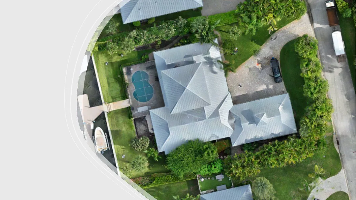
Drone aerial — residential property survey
02
Survey Services for Construction
Precise site surveys and layout services — keeping your project on grade and on schedule.
As-Builts
Delivered Fast
Layout
Stakes & Control
Florida
South & Central
What We Do for You
- Construction Layout & Staking
- As-Built Surveys
- Topographic Surveys
- Boundary & Lot Surveys
Why SurveyFy
- Field crew experienced on active construction sites
- Coordinated scheduling with GC and subs
- CAD deliverables formatted for your design team
- Residential, commercial & infrastructure projects
- South & Central Florida
Typical Deliverables
Staking & layout field notes
As-built CAD drawings
Topographic survey with DTM
Boundary survey & sketch
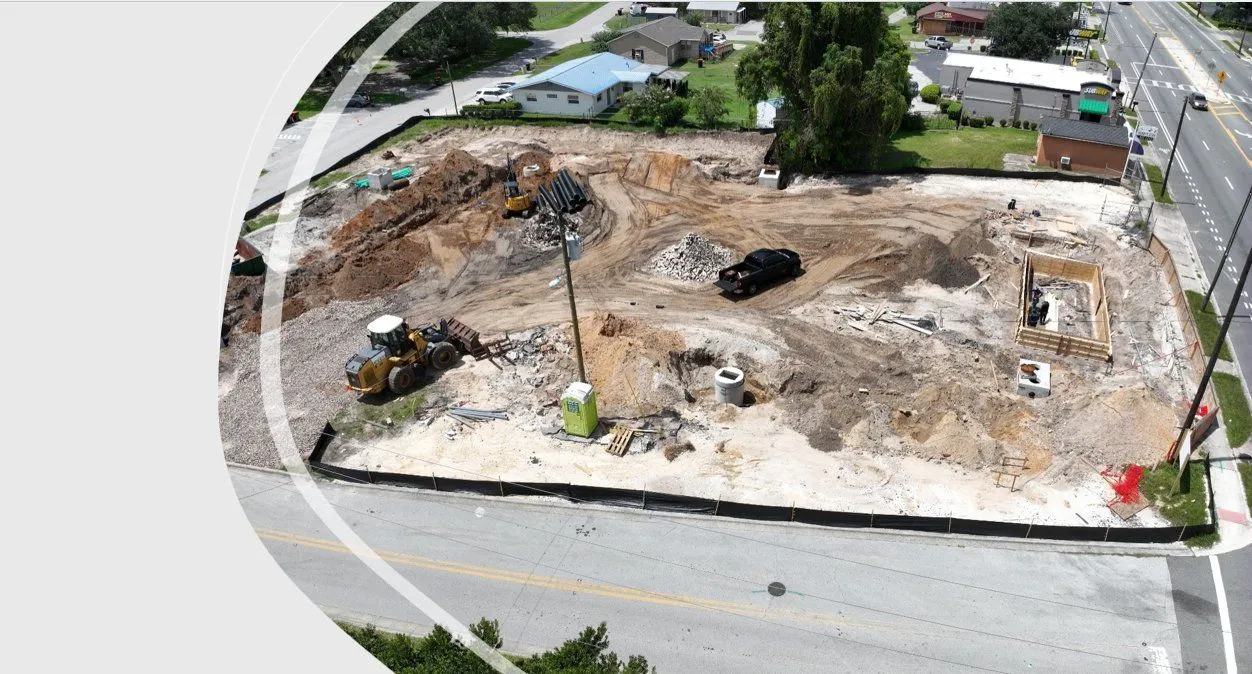
Drone aerial — active construction site survey
03
Survey Services for Engineers & Agencies
High-accuracy topographic and boundary surveys formatted for design and permitting workflows.
Multi-Method
Total Station, LiDAR
CAD Ready
Your Preferred Format
Florida
South & Central
What We Do for You
- Topographic & Design Surveys
- DTM/DEM Surface Creation
- Boundary & Right-of-Way Surveys
- Platting & Legal Descriptions
Why SurveyFy
- CAD deliverables in your preferred format, ready for submittal
- Experienced with municipal and county submittals
- LiDAR and total station methods
- South & Central Florida
Typical Deliverables
Topographic survey CAD file
DTM/DEM surface model
Boundary survey & legal description
Subdivision plat
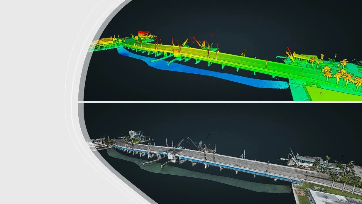
Bridge corridor survey — elevation gradient with bathymetric profile (top) and colorized point cloud (bottom)
04
Survey Services for Utilities & Energy
LiDAR corridor surveys, solar farm site data, and FAA obstruction letters — South & Central Florida.
LiDAR
Corridor & Vegetation Mapping
FAA
Obstruction Letters
Florida
South & Central
What We Do for You
- Vegetation Encroachment Analysis
- Tree Surveys & Inventory
- Solar Farm Surveys
- FAA Obstruction Letters
Why SurveyFy
- In-house LiDAR — no subcontracting delays
- Corridor surveys at scale across Florida
- Solar site survey experience
- Signed FAA obstruction letters
- South & Central Florida
Typical Deliverables
LiDAR point cloud & encroachment report
Tree inventory GIS dataset
Solar site topo & legal description
FAA obstruction letter
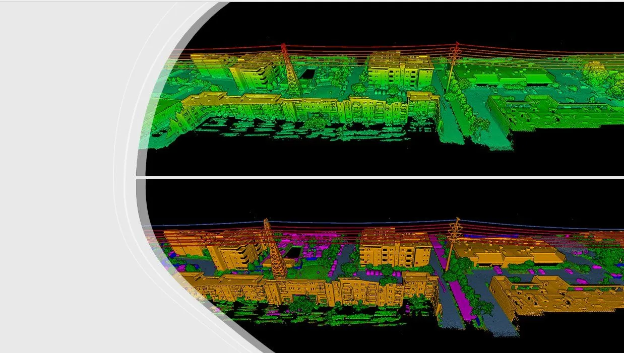
Classified LiDAR point cloud — power line corridor and vegetation analysis
05
Survey Services for Environmental Projects
High-resolution spatial data for environmental, coastal, and ecological survey projects.
300 Acres/Day
Airborne LiDAR Capacity
Bathymetric
Marine & Coastal Surveys
Florida
South & Central
What We Do for You
- Drone & LiDAR Mapping
- Wetland & Environmental Surveys
- Tree Inventories & Vegetation Mapping
- Bathymetric & Coastal Surveys
Why SurveyFy
- In-house drone, LiDAR, and marine equipment
- Federal and state permitting data formats
- Drone boat for coastal and waterway surveys
- GIS-ready deliverables for environmental teams
- South & Central Florida
Typical Deliverables
LiDAR point cloud & orthophoto
Wetland delineation map
Vegetation inventory GIS dataset
Bathymetric survey & contour map
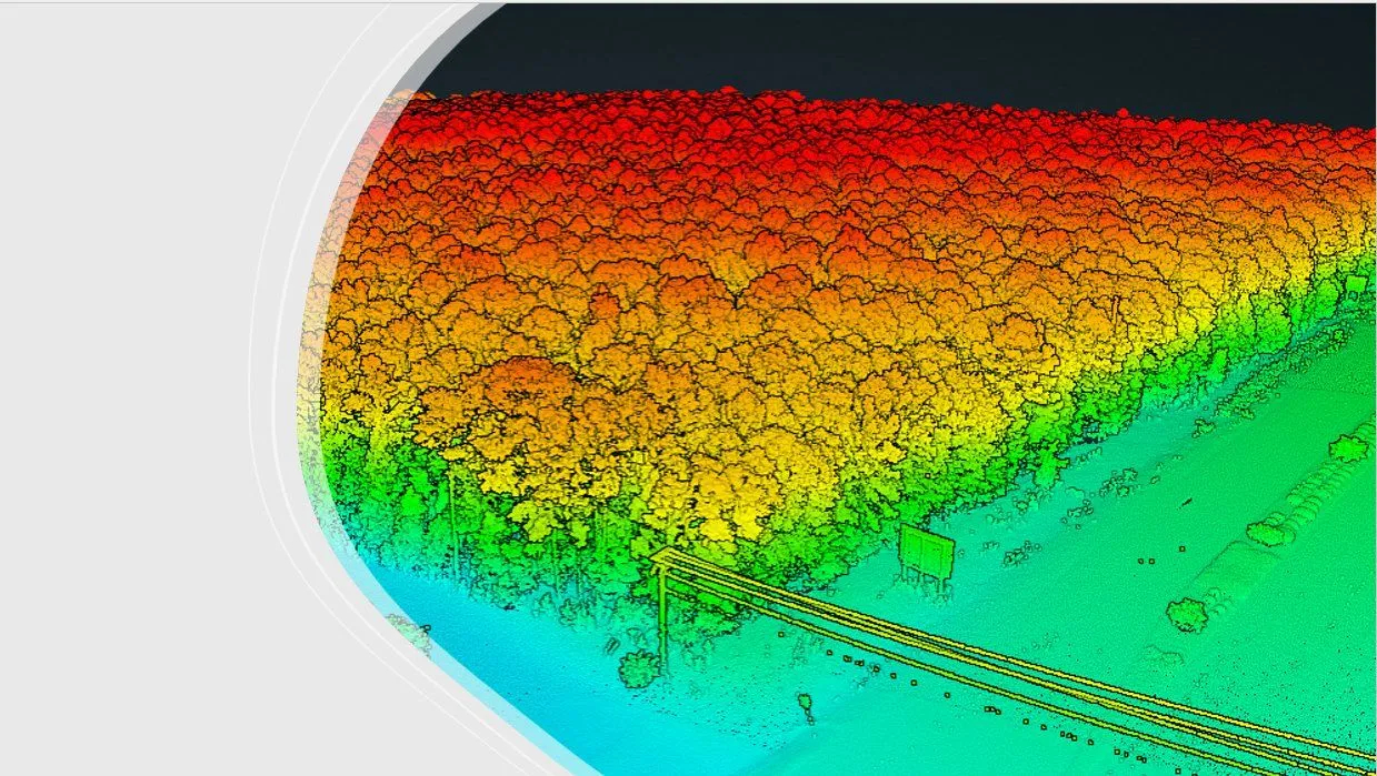
LiDAR point cloud — elevation-colored canopy and vegetation mapping
06
Survey Services for Property Managers
Boundary, elevation, and condition surveys for commercial properties, HOAs, and building portfolios.
Portfolio
Multi-Property Surveys
HOAs
Residential Communities
Florida
South & Central
What We Do for You
- Boundary & Property Surveys
- Elevation Certificates
- Topographic Surveys
- As-Built & Improvement Surveys
Why SurveyFy
- Experience with HOAs, commercial parks, and portfolios
- Coordinated access scheduling for occupied properties
- Signed & sealed deliverables for insurance and permitting
- Residential and commercial properties served
- South & Central Florida
Typical Deliverables
Boundary survey & sketch
FEMA elevation certificate
Topographic survey CAD file
As-built improvement survey
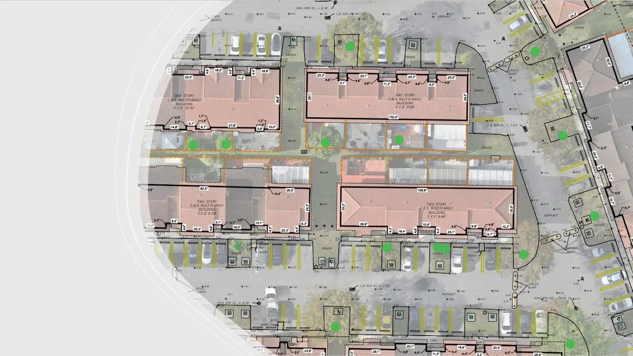
Aerial survey overlay — multifamily property with building dimensions and FFE


